Jacks River Falls
Relocating to North Georgia mountains? Check this Out! Great Georgia Properties

Fall size: Runs 200' and loses 60' in elevation
Beauty Scale: 10
(1-worth seeing-10 awesome)
Activities: hiking, camping
Facilities: none
Fees: Forest Service fee parking
Closest town: Cisco, Georgia
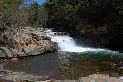
The most scenic single feature in the Cohutta Wilderness and the most frequently visited area despite the 4.6 mile hike to the falls. Its beauty, power, and great swimming area draws a lot of visitors. The falls is series of a couple of small waterfalls, one large waterfall, and some cascades that are perfect for swimming. Descending in stages, the surging water piles up against boulders and rock walls, carving swirlholes in the bedrock. Well worth the hike Jacks River Falls is in a rugged setting of exposed rock flanked by hemlock and white pines.
Directions
Southern trail head from Blue Ridge Georgia
From the intersection of US 76 and GA 5 just north of Blue Ridge, travel north 7 miles on GA 5 to Old Highway 2 and turn left. At 6.9 miles are Fightingtown Creek and McKinney Crossing. At 9 miles the pavement ends. At 10.5 miles, after a long climb up the mountain, look for the sign "Cohutta Wildlife Management Area, Watson Gap." At Watson Gap turn right on FS 22 and travel 3.6 miles to Dally Gap and Jacks River trail head.
From Chatsworth take US 411 north 13.2 miles
to Cisco community and intersection with Old Highway 2 (also known
as FS 16). At .7 mile pass County Road 169 on the right. The pavement
ends at 1 mile. Take the right fork at the Y intersection at 1.6 miles.
(County Road 210 bears left.) At 3.2 miles, FS 17 comes in from the
right, FS 16 goes left. Follow FS 16 just across the Tennessee state
line to the northwestern trail head of the Jacks River Trail.
For more information:
Some roads are closed depending on weather conditions, so it is recommended that one call the Cohutta Ranger District of the U.S. Forest Service at (706) 695-6737 in advance of a trip to check road conditions.