Directions:
From Blairsville Georgia take US 19 & 129 south for 8 miles.
Turn left (east) onto Georgia 180. Go 9 miles to Georgia 180 Spur and
turn left (north). Go 3 miles to the Brasstown Bald parking area
From Cleveland Georgia take GA 75 north through Helen to GA
180; turn left (west) onto GA 180 (also GA 66); go 6 miles; turn right
onto GA 180 spur; continue 3 miles to Brasstown Bald parking lot.
From Hiawassee Georgia Take US-76 [SR-17] (South-East) 2.8 miles Bear
RIGHT (South) onto SR-17 [SR-75] 6.3 miles
Brasstown Bald Park will be clearly marked on the right Total
Distance: 9.1 miles
Estimated Time: 12 minutes
Activities: hiking, breathtaking views, Video show, picnic area, bookstore and gift
shop, hiking trails, parking lot , restrooms, exhibits, observation
deck, brochures, concessions, shuttle bus.
Fees: Parking $3.00 per vehicle
For a fee of $2.00 per person, a shuttle bus
can carry visitors from the parking area to the visitor center, weekends
during April and May then daily from Memorial Day through the end
of October. The short .5-mile paved trail leads from the parking area
to the visitor center on the bald is steep but has many benches to
rest along the way.
Closest town: Hiawassee, Georgia
For more information:
Brasstown Ranger District
1881 Highway 515 P.O.Box 9,
Blairsville, Ga. 30514
Phone: 706-745-6928 Fax:706-745-7494
Visitor center phone (706) 896-2556.
Brasstown Bald Hiking Trails
Part of the Chattahoochee
National Forest there are four hiking trails, including the paved
summit-access trail. All start from the parking area at the bald.
Simple maps and descriptions of all four trails are available in the
Forest Service brochure "Trail Guide to the Chattahoochee-Oconee
National Forests." The maps covers the area of Hiawassee, Jack's
Gap, and Blairsville showing three of the trails—Arkaquah Trail,
Wagon Train Trail, and part of Jack's Knob Trail.
Arkaquah trail
About 5.5 miles. There is a
difference of 2,500 feet in elevation as the trail descends westward
along a ridge top from its beginning in the Brasstown Bald parking
area to its end at Track Rock Gap Archeological Area . With a difficulty
rating of moderate to strenuous, this is not considered a beginner's
trail. Blue Bluff Overlook is on the trail. Hikers pass Chimney Top
Mountain and will be able to see Rocky Knob to the south. Plott Cove
Research Natural Area, which is rich in herbs, wildflowers, and northern
hardwoods, is north of the trail at Cove Gap. To reach the western
end of the trail at Track Rock Gap, go east of Blairsville on US 76
for 6 miles, turn right onto Track Rock Road and go 3 miles.
Jack's Knob trail
About 4.5 miles. Built in the 1930s by the
Civilian Conservation Corps and reconstructed in the 1980s by the
Forest Service, Jack's Knob Trail is limited to foot traffic and is
rated moderate to strenuous. Descending southward from the parking
lot along a ridge following the boundary of Towns and Union counties,
it crosses GA 180 in Jack's Gap [Fig. 30(9)] at an elevation of 3,000
feet and ascends Hiawassee Ridge past Jack's Knob [Fig. 30(10)], elevation
3,805 feet. Jack's Knob Trail joins the Appalachian Trail in Chattahoochee
Gap near the source of the Chattahoochee River.
Track Rock Archeological Site
Like the Mayan hieroglyphics of southern Mexico
and Central America, the ancient petroglyphs carved into three large
soapstone boulders on the west side of the road here have resisted
translation. Referred to by the Cherokees, who inhabited the area
at the time of the white settlement, as degayelunha, or "printed
place," the rocks have been enclosed in metal cages to protect
them from vandals and graffiti scrawlers. Though the stones are weathered,
their mysterious inscriptions are still discernible to travelers who
take time to stop here near the foot of Brasstown Bald.
Directions: On Track Rock Road off US 76, northwest
of Blairsville and 4 miles southwest of Young Harris.
Wagon Train trail
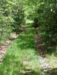
Originally constructed as a portion
of Georgia Route 66, this road was built in the 1950's by convict labor.
For years, dozens of local families formed a wagon train and traveled
the seven winding miles from the town of Young Harris to camp and socialize
on the Bald. The road, now only open to hikers and horses leads into
Brasstown wilderness.
The Brasstown Bald parking lot is
the upper elevation entrance to this trail. To find the entrance, go
between the bookstore and the concession stand located in the parking
area. Take the paved trail and turn right (east) onto a dirt road.It
is a moderate, 5-7 mile walk with fine views. Near the summit, the trail
passes remarkable cliffs and boulder fields where rock tripe, lichens,
reindeer moss, old-man's beard, and club moss flourish. In early spring,
silverbell, serviceberry, mountain buttercups, white saxifrage, toothwort,
cinquefoil, bluets, highbush and low-bush blueberries, white and purple
violets, solomon's seal and plume, pussytoes, and four varieties of
trillium can be seen blooming along the trail. The trail ends at private
property 2 miles south of Young Harris.
